Aside from the fact that we are totally excited for any news involving local aviation, there was a much bigger reason that we have been posting information to spread the word about the commercial service from Frontier Airlines that will be starting out of Provo Airport this June.
This is the story: The mayor of Provo City has an awesome blog. He posts daily about interesting things happening in or around Provo and recently announced a contest. He Had 4 tickets for the inaugural flight on Frontier from Provo to Denver that he wanted to give to the person or people that could spread the word about the upcoming service to the most people. So, we took the challenge. The winners were announced today, and guess what?!?
We got it!
So, Dane and I will be happily enjoying two seats on the first commercial flight out of Provo. I can't believe it!
Don't worry, we will be sure to take lots of pictures and post all of the highlights!
A few months back, Frontier Airlines announced service from Denver Int'l Airport into Provo! The inaugural flight out of Provo will take place on June 21st, with the first flight leaving around 8:00 in the morning. They will have one arriving flight and one departing flight each day, with dozens of connection options that can be made through their network in Denver. Their Denver hub is their biggest hub, thus making the options almost all encompassing on a national scale.
This is their route map. Click to enlarge.
This is the jet type they will be flying in. An Embraer 190... a relatively new mid-size regional jet.
The best news about them coming to Provo? The prices are comparable to flying them out of SLC... in many cases even cheaper!
As an aviation student/nerd, I am excited to have a large commercial jet coming into Provo regularly. I think it is good for the economy and to help the Provo airport grow.
Also, Frontier is acting as a type of Guinea Pig for other airlines... if they are successful, then more airlines will be attracted to fly into and out of Provo.
I was thinking about the benefits of this the other day. I already ride my bike out to the airport all the time for school. It takes be about 20-25 minutes from where I like in east Provo. I could lock up my bike and be in Denver within 2.5 hours of riding away from my house! It would be so fun to just go to Denver to visit family, go to a Rockies game, enjoy some food, and fly back. That is so much more attractive than driving all the way up to SLC, parking, fighting lines at security, etc.
Please, spread the word on this service!! It is good for our local economy, and so convenient!
We sure have come a long way from sitting by the boppy like this, huh? She still needs a little help sitting up, but is getting really good at holding herself up. Some of Lynlee's favorite things to do these days include laughing, standing (with help, of course), holding toys, sucking on fabric--especially mom's clothes, rolling from tummy to back, and scooting her body around on the floor.
This is from a few nights ago. We have found that Lynlee sleeps a lot better when she has a full tummy, but sometimes it is a bit of a challenge to get her to fill it up. :)
After getting some zzz's, Matt and started the familiar routine of checking the weather, checking our route, gathering all of our things and receiving a flight and weather brief from the Briefer. We got back to the plane, and thankfully it was right where we had left it. We had gotten our tanks topped off the day before, so we didn't have to worry about fueling up. We did all the standard pre-flight inspections, set up our cockpit and made sure the plane was balanced the way we had planned.
During the pre-flight
Emily and me in front of the DA42
One of my best friends from High School, Emily, came down from Sunnyside to say hi and see us off with my parents. It was fun to see her and share what I've been doing for the last two years. We visited briefly, but all too soon, we got into the plane and prepped to leave. We loaded our flight plan into our G1000 (our glass avionics flight-deck... no round dials here! This is similar to the GPS unit that Garmin makes for cars, but on steroids! And way more expensive... and it can do 100 times more), warmed up the engines, taxied down and took off!
Notice what my Dad said there at the beginning? Punk! Go be friends with that chump in Pasco!
My dad shot some video of the takeoff also...
We couldn't pass by the opportunity to show off, so I performed what is referred to as a "soft field" take off. Long story short, you lift off the ground, level off just 10-15 feet off the ground and keep heading down the runway picking up speed. Once we got to the end of the runway, I pulled back a little aggressively and took advantage of all the extra airspeed to rocket into the atmosphere. If I remember correctly, my instruments indicated that we were climbing at about 2500 ft per minute there for just a second or two... that's fast by the way.
We took off to the east, made a left climbing turn 270 degrees so that we could clear the Rattlesnake Hills, and rocketed up to FL180. Our climb was quick and efficient because I set the autopilot for the climb out. It held the best climb airspeed (90 kias) with precision, and consequently we wasted no energy getting up to our chosen altitude. Can I just say that the auto pilot in this plane is amazing? The autopilot is integrated into the G1000 which makes it more accurate, precise and robust. It works in perfect synchronization with all the different functions of the flight-deck.
This shows us our heading, altitude, vertical speed, indicated speed, and much more.
This shows all of our engine info (far left, mostly off screen), moving map, flight plan and more. Up top is our ground speed... 204! That is 235 mph.
We got in contact with Seattle Air Route Traffic Control Center (ARTCC) quickly, picked up our IFR clearance, and shortly after leveling off at FL180 received clearance to fly direct to Provo from our position.
Flying high (FL180) above Oregon, shortly after crossing the Columbia river.
On our way to Washington, it took us about 3.5 hours total to get to Prosser. On this trip, we planned to go non-stop and get back as soon as we could. We had enough fuel, and we hoped that our bladders would be big enough to handle the trip. Luckily for us, there was a pretty decent tail wind and we got as fast as 204 knots ground speed, and about 170 ktas. That is the fastest I've ever flown (well, flown my own plane), and we made great time back to Provo. Our total flight time was 2 hours and 45 mins from startup to shutdown. Not bad considering that the drive takes about 11-12 hours. :)
Our flight track back to Provo
Coming back, we ran into some clouds with some decent vertical development. Usually that means turbulence, ice accumulation, etc. Not a good idea for our tiny little plane to fly into. We skirted around them, but once we got over the Great Salt Lake, we opted to finish our flight VFR to skip the clouds and expedite our arrival into Provo.
Our arrival took us just west of SLC int'l airport, and then just east of Kennecot. They had us fly above the traffic arriving into the Int'l airport, over the Oquirrh Mountain Temple. After passing the point of the mountain, we made a straight in approach for runway 13 and landed just in time to beat out an approaching storm.
That was it! I hope you enjoyed following along with my long rants and complex explanations. I did this mostly as a means of journal keeping and to be able to look back at it in the future for memories. Despite that, I hope you learned something new about aviation, me or our part of the country.
This is what has been going on at our house lately:
Lynlee found her feet (and Louie)
She has been really interested in holding her own bottle, but she can't really keep it in the same place for long. I am pretty sure she just likes holding stuff, and has no idea that what she is holding happens to be the item feeding her. She'll get there. :)
We have been going on lots of walks lately using our faux-mobi wrap and another carrier from my mother-in-law.
And here is another exciting moment. Lynlee is starting to have fun holding onto toys. This is a rattle, but again, I am not sure that she has made the connection that the sound coming from the rattle is being made by her shaking it.
It has been so exciting to watch her grow. She rolled over for the first time a few days ago. I only have 6 more days of work, and I am glad to say that I won't miss anything else!
We had a relatively uneventful departure from Boise. We had a fast climb up to FL180, and cruised towards Pasco. The most eventful part of the cruise portion of our flight was changing frequencies from one controller to another (i.e. not exciting). It was kind of cool that We pretty much flew right over the interstate route I take to drive home. It was a nice feeling to know that we were going more that twice the speed of the cars on the freeway.
This is what our flight looked like... pretty uneventful until the end. More on that to come...
When we were about 15 minute outside of Pendleton, ATC had us start descending at Pilot's discretion (as fast or slow as we wanted), so we started preparing for our approach in the Tri-Cities airport. Begin the funniest story of the trip: So there we were, descending on our arrival in Pasco. We were told to switch over to Chinook Approach, and did so. On the other end was a some what older sounding lady. It was obvious that the Tri-Cities area was not busy, and she gave us the weather info at the airport, and asked what we would like to do. We could have just accepted a visual approach (the easy way), but I was in the mood to shoot an approach. Remember the charted approach we flew into Boise? Well, I let the lady on Chinook Approach know we wanted to shoot and approach. She told us it was up to me, since it was so slow... we had a few options to choose from. I chose the RNAV (GPS) Y RWY 21R approach because (to my best recollection) the winds were 210 @ 8 knots... pretty much we would have a perfect 8 knot headwind on approach, which is pretty favorable. The thing I didn't think too hard about was that it would be no big deal to land with an 8 knot crosswind on the runway that was directly in front of us. Choosing the approach that I did would require us to fly to the exact opposite side of the airport, flip around, and then land. How much did this add to our flight? Oh, maybe, say... 25 minutes! Well maybe that doesn't sound like too much to you, but when you consider that the entire flight was only 1:36, the fact that I spent 1/5th of it touring the vast farmlands of eastern Washington is pretty pathetic, especially when I could have simply gone straight in to Runway 30.
This gives you a better idea of my stupidity. See how just before I get to the OR/WA border, I am heading directly toward the airport? Then I veer off to the right... yeah, I took the long way.
This story wouldn't be as funny if Matt and I didn't have to use the restroom so bad! As we are doing our part to contribute to global warming over the farms of Washington, I am thinking to myself "wow, I have to go to the bathroom really bad... why is this taking so long?"
Another funny story teaches all of us a lesson about Air Traffic Controllers. A pilot (and Controller of course) has to know what a controller sees when they are looking at their radar screen.
What ATC sees on their radar screen.
They see little targets, with the name of the airplane, airplane type, altitude, speed and direction. They use all of this information to separate traffic. While we were flying the aforementioned approach, the lady on Chinook Approach gave us some vectors (directions to fly) to keep away from some traffic. She told us to fly some heading like 350. Then, a few minutes later she asked why we weren't on the heading she gave us. This is where it get's tricky for you non-aviators. I explained to the controller that the nose of our plane was pointed in the direction of 350 just like she asked, but we had a direct left crosswind. This caused our plane to be moving over the ground (this is called ground track) in a direction closer to 360 or 010 instead of the direction our nose was pointing. Even I know that controllers only see an aircraft's ground track on their radar screen. We could be flying backwards for all this lady knew... the bottom line is that all this lady could see was our direction and speed over the ground. But as a controller, you have this extremely basic little piece of knowledge that the wind is blowing up where this plane is (she had just given us the weather info for crying out loud) and that that could be affecting them in a variety of ways. Bottom line, I felt like I knew more than this lady. Anyway, Matt and I had a good chuckle that this lady had to even ask us that question.
So, we landed at the airport, made our way over to the Local FBO (Fixed Base Operator, or flight center) to get topped off on fuel and oxygen. While we were waiting, one of the employees, about my age, approached me and asked if we were flying the Twin Star. I responded in the affirmative, to which he replied "I hate to tell you this, but your plane is ugly." What the...? I have no idea who this guy thought he was... after some more conversation, I found out he doesn't even have any pilot licenses and ratings. He is only a mechanic who works and planes and fills them up. Dirtbag... Matt and I spent the rest of the trip trash talking him.
Anyway, we took of from the Tri-Cities and did a quick 5-10 minute VFR flight to Prosser (S40). I was actually surprised that when we tuned into the CTAF (common traffic advisory frequency... this is a frequency assigned to an airport that doesn't have a control tower. All the pilot has to do is self-announce their position in relation to the airport, and keep an eye outside for other traffic) their were two other planes preparing to land at Prosser also. I didn't expect there to be too much action, but I later found out that Prosser actually has a bustling little community airport.
Another funny story was what transpired when we landed. We had a pretty uneventful landing, but when we parked the airplane, we had attracted quite the small crowd of admirers. We had 3 or 4 older men taking pictures with their phones, asking questions and saying things like "thanks for coming to Prosser!" It was pretty awesome to get some positive attention after talking to the jerk in Pasco.
Immediately after arrival into Prosser, letting the engines cool.
Nice shot mom... walking off the plane.
Pushing the plane into the parking spot.
Using my Boy Scout skills to make sure the plane doesn't go anywhere, with an admirer in the background.
After we got the plane locked and secured, we went to my parents house (sometimes I call it home, at the risk of getting hassled by my wife) and had a delicious dinner made by my dad. Matt already wants to go back for the food. We enjoyed the beautiful sunset and views and took a small tour of Prosser. My parents spoiled us, and made us feel very special and welcome.
For those of you who don't know, there are two types of ways to fly... there is IFR (instrument flight rules) and VFR (visual flight rules). IFR is much more regulated, with the vast majority of the flying taking place on specified airways (think "highways in the sky") and routes. VFR is still regulated, but more often than not it is more convenient to just fly off airways. VFR really comes in handy when you need to skip around clouds and storms.
So, now that I have explained that, it will make sense (hopefully) to you that we filed an IFR flight plan. This meant that we will be talking on all the same frequencies as the airliners and flying on similar routes, but at lower altitudes since our airplane's altitude limitation is 18,000 feet (or in pilot terms, flight level 180, for "flight level one-eight-zero"). The only problem is that if we were to fly all of the exact routes required for our IFR flight plan, it would take us right through some really big clouds on our climb from Provo to FL180. We didn't want to do that mainly because we are not allowed to and also because we would likely accumulate ice if we flew through the clouds, making flight some what dangerous. Our plane does not have protection from ice accumulation like all airliners and sophisticated jet transports, thus we wanted to steer clear. Our solution to this problem was to takeoff from Provo under Visual Flight Rules. For us, this meant we could pick our own route through the clouds, then call Salt Lake Approach Control (the local Air Traffic Control agency) and change over to our IFR flight plan. We would then be required to follow those separate set rules. Confused yet?
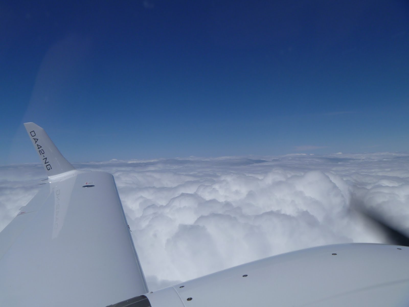
So, takeoff VFR we did! We flew out over Utah Lake, found a hole in the clouds, and poked through without ever touching a cloud.
This is what we saw when we got above the clouds. Normally we would be able to see Utah Valley and Salt Lake Valley.
Another shot looking off the wing.
I should mention that that funny looking mustache on Matt is actually an oxygen mask. It has two nose prongs and puts out a steady supply of oxygen to keep us alive in the thin air.
Once we got going, everything was relatively uneventful. We climbed up to our cruising altitude, set cruise power and enjoyed the ride. While in cruise, we monitor the engine instruments, fuel levels and temperatures (it's cold at FL180! -24 degrees celsius on our way to Boise... it would be bad if our fuel froze!) and our flight plan progress. We look at checkpoints in our flight plan and compare the planned data to our actual data. For instance, we look at our calculated ground speed versus our actual groundspeed. You'd be surprised how accurate we can be with just the forecasted winds/temperatures and a pilot's slide rule (E6B). The purpose of checking the accuracy of the flight plan is to make sure we are aware of how much fuel we are really burning. Are we going faster than planned? Well, then we are using less fuel. Slower? Then more fuel is being used. All this is pretty quick to calculate though, so we also socialize quite a bit. Luckily Matt and I get along really well. As we got closer to Boise's airport (KBOI), ATC started having us descend in preparation for the approach into Boise. We were able to skip around a few clouds, and we were cleared to fly the RNAV(GPS) Y RWY 28R approach (pronounced: Are nav gee pee ess yankee runway two-eight right) and we landed without any even. We got fuel at a jet center, grabbed a quick bite, and used the restroom. we then did a brief pre-flight and taxied FOREVER to the departure runway.
I am currently working on my commercial license and I have been busy trying to balance being a stay-at-home dad, flying,a full load of classes, work and my church calling. About 2 months ago my flight instructor, Matt, and I were discussing how I would accomplish some of the flight requirements for my license. I told him that I really wanted to fly back home to Washington and fly into the little airport in the town my parents live in. He thought it would be fun, but he is also as busy (if not more) as I am, and said it would have to wait until the end of the semester. We decided on a date at the end of April and hoped for great weather.
We got to the week before the flight, and Matt and my eyes were checking the weather forecasts a dozen times a day. We were checking the forecasts for 3 cities too... Provo, Boise (a halfway stop for the trip to Washington) and Prosser (my "hometown"). We were actually biting our nails all week long because of precipitation. That was surprising, because of the (for you weather buffs) relative high pressure over the entire area, Provo included. In fact, Provo was looking the most threatening as far as cloud cover and precipitation (For those of you who don't know, we can't fly through clouds in UVU planes because of insurance risks, even though Matt and I are technically certified for flight through and in clouds).
Our day of anticipation came and Matt came to our house for breakfast and to be my ride out to the airport. We had a delicious breakfast bagel, did a last minute check of the weather, called in our flight plan (again, FYI... we have to call a "flight briefer" and give them our planned route so they can work us into the routes of all the other air traffic out there. They also give us a weather observations, forecasts, special notices for airmen, etc), and brought all of our maps, charts, calculations, info manuals, emergency gear and overnight clothes. As you can see, a lot to prepare for!
This is an example of a "sectional chart". It is one of two types of maps I used to plan my route to Washington and back.
Matt and I got out to the airport, dispatched our airplane (334TS), and printed off some last minute weather reports for the flight. On a side note, I have to tell you about our plane from a plane nerds perspective. Our plane is a DA42 Twin Star. It's a twin engine, carbon fiber airplane with turbo charged diesel engines. In normal planes without turbochargers, performance decreases dramatically as you climb. In our turbocharged aircraft you can keep climbing to significant altitude without degraded performance. Well, our specific plane, 334TS (you have to say it like this... three three four tango sierra) was fresh off of a visit to the Diamond Aircraft factory to get a new set of engines... upgraded engines! The old ones had a lot of problems, but were still great. They produced 135 horsepower and were a great upgrade from the single engine planes I've trained in as far as speed and climb performance. Let's be honest, those are two of the funnest parts of flying... horizontal and vertical speed! Well, these new engines have 168 horsepower each, and have bigger turbos too. What does that mean? Better high-altitude performance... more on that later.
Matt and I did our pre-flight inspection and walk around. We had all the tanks topped off (we have four fuel tanks... one 25 gallon tank in each wing, and one 13.5 gallon auxiliary tank in each engine nacelle. About 77 gallons total... enough for almost 6 hours of non-stop flying) with Jet A and got settled in the plane.
The weather looking east. Normally you would have a beautiful shot of Mt. Timpanogos here.
The weather looking west. Much better, with some holes in the clouds to shoot through.
A great view of the new engines and fresh paint job.
334TS. You can see here that the flaps are down for part of the pre-flight check. Matt is in blue.
Matt and I did all of our necessary preflight prep, including hooking up the oxygen (we would be flying at 18,000 feet to stay out of the clouds, pick up favorable winds, and... just because we could! Above 12.500 in an unpressurized aircraft it is required to be on oxygen per Federal Aviation Regulations), getting local weather conditions and other info from the tower and taxiing to the runway.
This is a boring video of us leaving the parking spot...
Our departure out of Provo (KPVU). If you listen carefully, you'll hear Provo's tower controller begin to address us at the end of the video.


